
This is what the new TTC subway map looks like
With less than two weeks to go until the Toronto-York Spadina Subway Extension opens, the TTC is set to begin installing updated maps throughout the subway that feature the sparkling new line.
You might have already noticed that wayfinding signage in the subway has been updated to reflect the new terminus of the western side of Line 1.
Didn’t realize TTC signs were already saying “to Vaughn” for the Line 1 expansion. pic.twitter.com/x1ZBanUJDh
— Josh McConnell (@joshmcconnell) November 29, 2017
The updates will be more noticeable in the days ahead as new signage goes up throughout the system. Today, TTC spokesperson Brad Ross tweeted out samples of the new maps, which will soon grace subway cars and station platforms.
You will start to see some new maps on your #TTC starting this week as we get closer to the opening of the Line 1 extension in just 12 short days pic.twitter.com/vxqv5etYo7
— Brad Ross (@bradTTC) December 5, 2017
The existing TTC maps foreground the arrival of the new extension with an outlined section between Sheppard West and Vaughan, but it won't be long before the new stops will actually light up on the Rocket trains' fancy above-door maps.
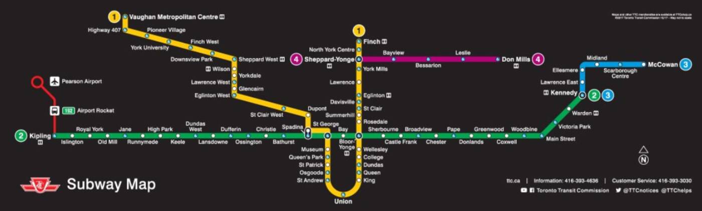 The Spadina Subway Extension is set to open on December 17, which will represent that first major addition to Toronto's subway network since the Sheppard Line opened in 2002.
The newly revamped maps also feature highlight transit hubs like UP Express connections and GO stations as well as commuter necessities, such as washrooms and accessible stations.
It's worth noting that these will likely be the mainstay maps going forward until at least 2021 when the Eglinton Crosstown is—fingers crossed—set to be completed.


