Saturday, May 26, 2012Mostly Cloudy 22°C
City

The 1856 panorama of Toronto

Posted by Derek Flack / January 12, 2011

Toronto Panorama 1856The Toronto panorama of 1856 might just be one of the coolest things I've come across during my digging through archival photos of Toronto. In fact, it's one of those things that I'm surprised I hadn't stumbled across before. As I was trying to determine whether or not there was enough compelling material to extend our series of historical photo posts on Toronto, I noticed that the Wikimedia Commons was particularly loaded with material from the year 1856 in what was otherwise a pretty sparse decade for their holdings.

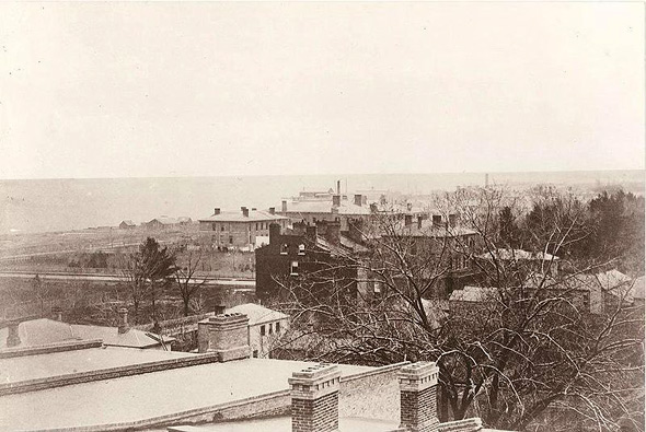
Lo and behold the reason for the preponderance of images is that 13 of them are related to one another. Shot by the photography firm Armstrong, Beere and Hime on the roof of the Rossin Hotel at York and King streets, the series of images doesn't quite form a seamless panorama, but given the technical limitations, the near 360 degree view of the old city is still remarkable.

What's also remarkable is that I could forget that I already knew about this panorama, too. Only yesterday was I fumbling through my bookshelves looking for a copy of Michael Redhill's novel Consolation. I wanted to give it a re-read in light of the fact that I've been doing so much with old photographs of late. Somehow, however, I didn't make the connection that Redhill's novel was in fact inspired by this very set of photographs that I had come across.

I suppose one of the reasons for my being so obtuse is simply that the novel -- or at least the copy that I have -- doesn't include the images themselves. This is actually quite a shame, as they're referred to a number of times, and, as I said, rather remarkable for their time.

So here it is. You can see the stitched file at this link, which is composed of the 13 photographs below.

201112-Toronto_1856_-_1.jpg

201112-Toronto_1856_-_2.jpg

201112--Toronto_1856_-_3.jpg

201112-Toronto_1856-4.jpg

201112-Toronto_1856_-_5.jpg

201112-Toronto_1856_-_6.jpg

201112-Toronto_1856_-_7.jpg

201112-Toronto_1856_-_8.jpg

201112-Toronto_1856_-_9.jpg

201112-Toronto_1856_-_10.jpg

201112-Toronto_1856_-_11.jpg

201112-Toronto_1856_-_12.jpg

201112-Toronto_1856_-_13.jpg
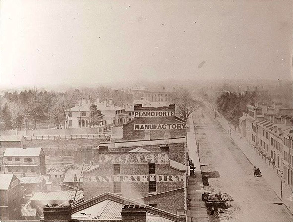
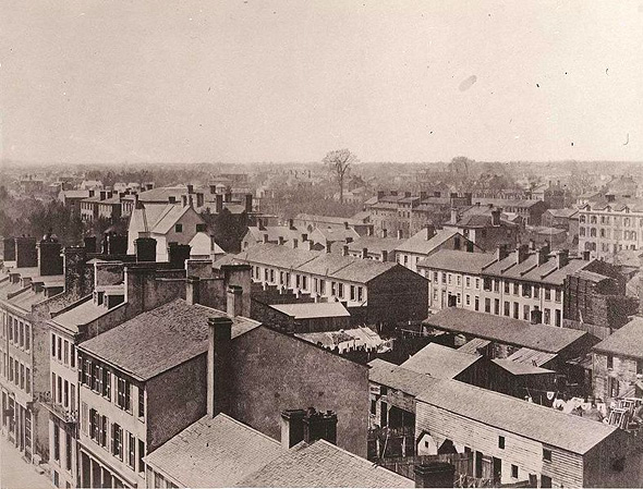
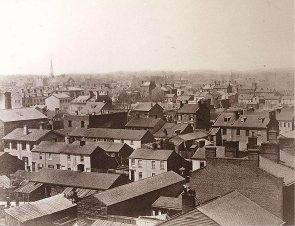
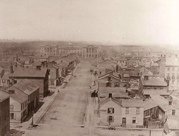
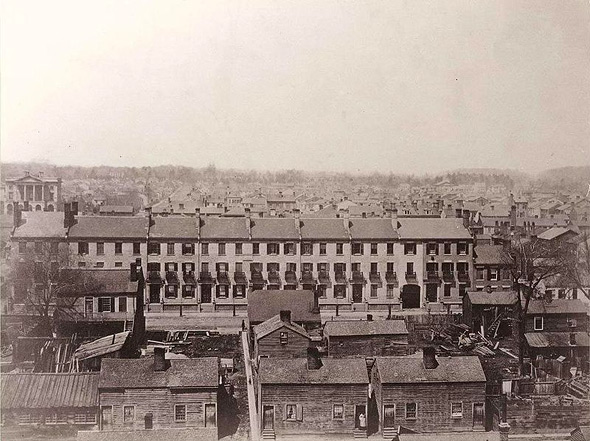
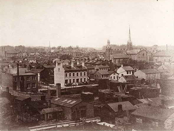
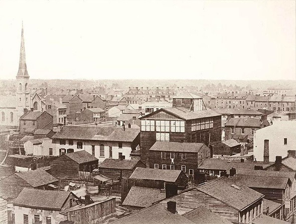
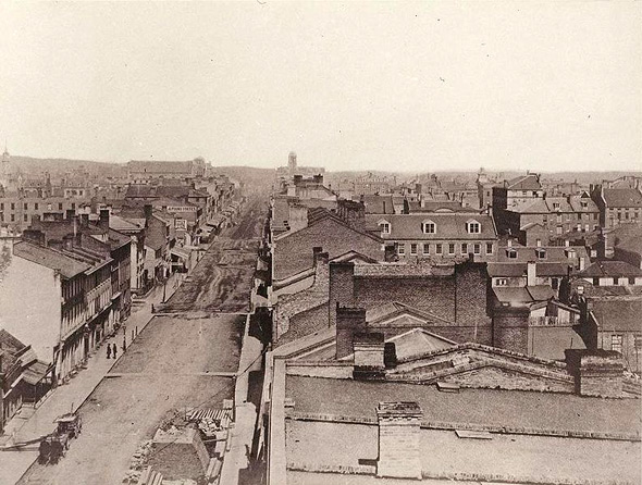
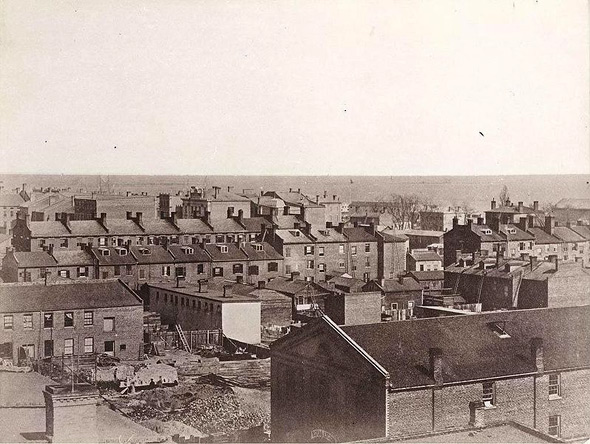
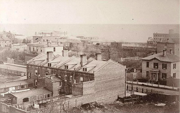
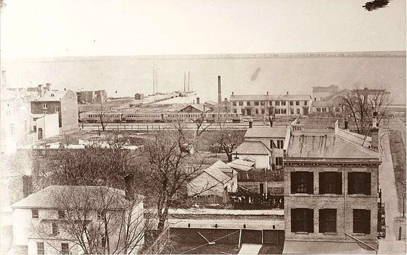
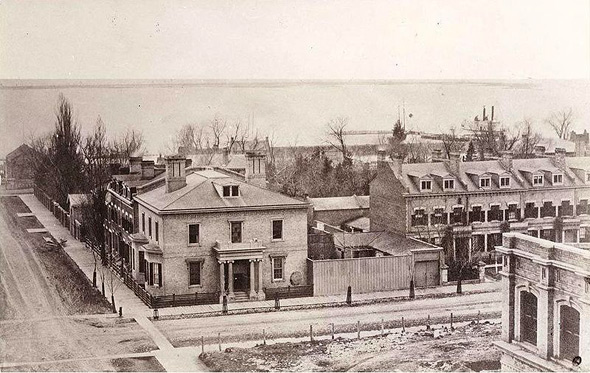
Images from the Wikimedia Commons.

Discussion

41 Comments

Stacey Brandford / January 12, 2011 at 10:41 am
user-pic
Great post. I'll have to find a copy of Consolation.
The Shakes / January 12, 2011 at 10:47 am
user-pic
Awesome pics! I'm kind of surprised at how few trees there were back then.
Nat / January 12, 2011 at 11:02 am
user-pic
Consolation = best book ever.
rick mcginnis replying to a comment from The Shakes / January 12, 2011 at 11:08 am
user-pic
They'd cut all the trees down to build the city. Also, the idea of landscaped streets with front yards and arbours shading the road was a later Victorian idea, which is why you see them in places like Parkdale and the Annex.
Bonk / January 12, 2011 at 11:21 am
user-pic
When I first found this panorama last year I wondered why I couldn't make out the original fifty-two feet tall Gibraltar Point lighthouse on the Island.
Eric S. Smith / January 12, 2011 at 11:46 am
user-pic
I don't think that you can beat "PIANOFORTE MANUFACTORY" for period coolness, but the whole thing is great (unpaved roads and boardwalks!).

(Nitpick: "composed of," not "comprised of.")
Derek replying to a comment from Eric S. Smith / January 12, 2011 at 11:53 am
user-pic
Right you are...on both points!
Sebastien Rahman / January 12, 2011 at 12:07 pm
user-pic
This is amazing! What a wonderful history Toronto has.. it's incredible that there was an archive of the Toronto landscape from 1856.

Best,

Sebastien
pat / January 12, 2011 at 12:32 pm
user-pic
Thank you! I love finding info about Toronto of old. When I have time, I research Leslieville, but it's great to see how it fits into the larger picture. At this time, Leslieville was Geo. Leslie & Sons Nursery, the "largest nursery in the Empire."
AC / January 12, 2011 at 12:35 pm
user-pic
What's the big building in photo #4? Osgood Hall?
cosmosuave / January 12, 2011 at 12:57 pm
user-pic
6th pic down that one church looks like Little Trinity beside TEC...
Janet Berkman / January 12, 2011 at 01:14 pm
user-pic
Wonderful images!

Some background on the the Rossin House Hotel and the Chewett family who built it can be found at http://torontofamilyhistory.org/simcoesgentry/26/chewett
iSkyscraper / January 12, 2011 at 01:31 pm
user-pic
Great photo, from pre-confederation nonetheless. Wow.

What a slapdash of mud, brick and wood. How quickly we forget how much the city has grown...

Yes, that is Osgoode Hall, located in the wood shantytown of what was then the rundown northern inner suburb of its day. The respectable part of town, lined with brick rowhouses, was to the east in the Old City. (Someone correct me if I am wrong).


fdr / January 12, 2011 at 01:33 pm
user-pic
I'm a bit confused about where they were taken. The posting says York and Simcoe? The "old hotels" posting says the Rossin House was at King and York and that it was demolished for the TD buildings. (Actually, the TD buildings aren't on that corner, the Standard Life Center is, although I could imagine this building might have been taken down at the same time that the TD buildings were under construction since it's all part of the same block) So are these photos from the roof of a building at the corner of York and King? If so, that must be Osgoode Hall up York Street in photo #4.
Derek replying to a comment from fdr / January 12, 2011 at 01:40 pm
user-pic
The photos were taken atop the Rossin House hotel, which is at King and York (not York and Simcoe). The post above is updated, but the Wikimedia Commons label (which tricked me) will need to be, too. Thanks!
Janet Berkman replying to a comment from fdr / January 12, 2011 at 01:41 pm
user-pic
Yep....York and King.
fdr / January 12, 2011 at 01:44 pm
user-pic
You can see Church of the Holy Trinity on the left side of #6 (it's now nearly surrounded by the Eaton Centre, the Marriott and the Bell Canada building, located behind Old City Hall).
Duane / January 12, 2011 at 01:52 pm
user-pic
Seems like quite the ghost town. Where are all the people?
skeeter / January 12, 2011 at 01:55 pm
user-pic
is that the eiffel tower in the 4th photo from the top? it was so much closer back then!
Derek replying to a comment from Duane / January 12, 2011 at 01:56 pm
user-pic
Early cameras required the use of much longer shutter speeds to expose images properly, so the majority of people in photographs from this period -- lest they were standing still -- would "ghost" out of the camera's ability to capture them.
AcadianDrifter / January 12, 2011 at 02:13 pm
user-pic
The last two images are a reminder of how the waterfront has moved. It was much closer at that time.

Notice the steamship in the distance in the next-to-last pic ?
Sean / January 12, 2011 at 02:13 pm
user-pic
What an incredible find!
fdr / January 12, 2011 at 02:27 pm
user-pic
I like the lady standing in the doorway of her ramshackle house in #5. Little does she know that in 150 years her little plot of land would be at the foot of the tallest building in the country, the 72 story FCP.
SNACKeR / January 12, 2011 at 03:43 pm
user-pic
That's fascinating, what a find!
Fig / January 12, 2011 at 03:45 pm
user-pic
Kudos Derek. Please consider doing a historical pictoral series on some other areas of TO as well.
Jeremy / January 12, 2011 at 05:31 pm
user-pic
When I read Michael Redhill's book and looked at the above photos around the same time, it had a very special resonance for me. I had done some family research and discovered ancestry in Toronto going back to 1832. The setting of the novel, I realized, was around the corner from an ancestor of mine - George Bilton, who was living on Jarvis in 1856.

He died in May 1858, having drinks near King and Yonge Streets, and I found an article in the Globe about him - mentioning he was the current president of the St George Society. Further research revealed the Society is still in existence, and that they had a PHOTO of Bilton! Sure enough, I found it at the Toronto Archives, and I later realized it must have been taken within a few months of the photos depicted above. It was hard not to imagine my ancestor sitting for a portrait in the (fictitious) studio from "Consolation" and the photographers planning their Rossin shoot. The novel brought back for me the Toronto that was in those days, and these photos make it even more concrete.
Stan / January 12, 2011 at 05:43 pm
user-pic
Thanks. It makes you wish the waterfront still looked like this.
Eric S. Smith / January 12, 2011 at 05:46 pm
user-pic
It sure looks like a little colonial frontier town in these pictures. The dirt roads, boardwalks, and wooden buildings all read as Wild West to the modern eye.
SNACKeR / January 12, 2011 at 06:22 pm
user-pic
Those are some really cool connections, Jeremy!
David / January 12, 2011 at 07:39 pm
user-pic
More information can be found about these pictures in a book celebrating Toronto's 175th anniversary. It will provide some sense of what you are seeing in each picture. The Toronto Public Library has 37 copies. The book includes many other interesting photos.

Toronto's visual legacy : official city photography from 1856 to the present
by MacKinnon, Steve, 1949-
Contributors: Dale, Michele. ; Teeple, Karen.
Year/Format: 2009, Book, 192 p. :
Sean / January 12, 2011 at 08:12 pm
user-pic
Even in those days, they didn't have bicycle lanes.
Adam Sobolak / January 12, 2011 at 09:11 pm
user-pic
Rossin House came down around 1969; it was a parking lot for a decade plus until Standard Life was built...
Denise / January 12, 2011 at 11:53 pm
user-pic
I love this series of photos of Toronto. It's so interesting to see the city's original mix of British and colonial architecture and how much the character of Toronto has evolved. It's sort of sad to see how many fantastic buildings have been demolished in recent decades... I'd love to have been able to see this Toronto for myself.
Tom / January 13, 2011 at 10:03 pm
user-pic
The book 'Lost Toronto' by William Dendy describes these images in detail

Larry replying to a comment from Derek / January 22, 2011 at 12:49 am
user-pic
Those two guys on the sidewalk in the 6th photo from the bottom must have been standing there for a while then.
Wayne / February 2, 2011 at 12:11 am
user-pic
I did a quick flash convertion with Pano2vr.
http://gardengnomesoftware.com/pano2vr.php
so I could "circle and zome in 360.

I would love someone from Google to stitch this.
Susanne McVinnie / April 5, 2011 at 08:20 pm
user-pic
I found these amazing photos researching my great-great-grandmother's diary! In October 1856 my great-great grandparents took their first trip back home to Vermont (from the farm they homesteaded in Illinois after driving there with a team and wagon mid-Feb. to April 1840). When the railroad came through town, they decided to take a new, faster way (a ship between trains) back to visit folks in Vermont. They mentioned that they took the ship, Ontario, from Lewiston, NY and landed at Toronto, where they went to the fair at 4 am. I googled "1856 Toronto Fairs" and Bingo! There certainly was a fair in Toronto in 1856! We lived 29 years in Windsor, Ontario, and two of my children went to U of T--these photos are amazing, especially the one showing the ship in the harbor, so close. I must now read the book that's been mentioned in others' comments here., and find out more about this fair, too.
susanne replying to a comment from Susanne McVinnie / April 6, 2011 at 08:19 pm
user-pic
Sorry, my bad. There is no sign of the fair. The Upper Canada Agricultural Association had exhibitions from 1846 on, but they moved each year between London, Hamilton, Toronto, Kingston, and other locations, eventually becoming set in Toronto. I haven't yet found what fair they saw on October 3, 1856, but it was in Toronto, and they walked there from the steamship and back. At least the photos show that could have happened--the ships came right in to the city, and the city was not that big. I'll keep looking for records of the CNE and the Royal Winter Fair and see what turns up. Still, these photos are just amazing.
susanne replying to a comment from Jeremy / April 6, 2011 at 08:23 pm
user-pic
What a great find for you, an actual picture of a relative who was living there at the time, and to have the stories about him--this must have been a thrilling discovery. Good for you!
susanne replying to a comment from Jeremy / April 6, 2011 at 08:24 pm
user-pic
Comment to Jeremy:
Fiona / February 10, 2012 at 06:50 pm
user-pic
What are those churches on the right of picture 6 and the left of 7? I thought at first they were St. Mike's and St. James', but I'm not so sure. Plus now I think St. James' is steeple-less in #8, across from what I presume to be St. Lawrence Hall?

Add a Comment

Other Cities: VancouverMontreal