The Corner of Roncesvalles and High Park

Posted by Rick McGinnis
Filed in City
May 25, 2009

The intersection of Roncesvalles, High Park Boulevard and Fermanagh Avenue, 1914At roughly the mid-point of Roncesvalles Avenue, the street intersects with High Park Boulevard on one side, Fermanagh Avenue on the other. The crossroads says a lot about the neighbourhood, past and present, and features an anomalous landmark building - the five-story apartment building on the northeast corner whose history has always been a bit of a mystery, especially since it was the tallest building in the area for decades.

I've had friends who've lived in the building, and with its wide, institutional-scale halls, there was always a suspicion that it wasn't originally built as residences. For as long as I've lived in the Parkdale-High Park area, the most common tale is that it was originally a TB sanitarium, built out in the leafy, airy western fringe of the city, close to High Park, a story that summed up an image of nursing sisters and concerned relatives pushing wheezing inmates, bundled under blankets in wheelchairs, down to the park for some life-giving fresh air. The story also explained the big Georgian-style home on the left side of the old postcard image of the intersection - a sizeable building whose natural function, so many of us thought, was as a nurse's residence for the "san" across the way.

It turns out we were all wrong. According to architectural historian Alec Keefer, whose knowledge of the streetscape of the old west end is peerless, it was originally the headquarters for York County Savings & Loan, who built it near their developments on High Park Boulevard and High Park Gardens, and various other properties in the neighbourhood. The original office building was the block at the corner of Fermanagh and Roncesvalles, and there were - though it's hard to see it today - storefronts on the ground floor. The company would send representatives door-to-door around the neighbourhood to collect mortgage payments at the first of the month, a legacy of the days when the human touch in banking was a little bit more punctual - and perhaps a bit more sinister.

The intersection of Roncesvalles, High Park Boulevard and Fermanagh Avenue, today
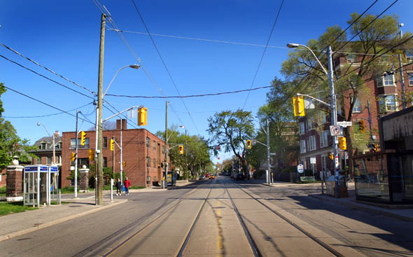
The postcard I've tried to duplicate with the photo above is postmarked May 2, 1914, and the storefronts are long gone. York County S&L apparently backed the wrong party in a provincial election, and were bankrupted not long afterward. The liquidation of the company was apparently overseen by a developer named R. Home Smith, who found that the company had a tidy profit after proceedings were through, and oversaw the conversion of York County's offices into apartments, and the construction of the eastern wing of the building.

High Park Boulevard looking east toward Roncesvalles, 1914
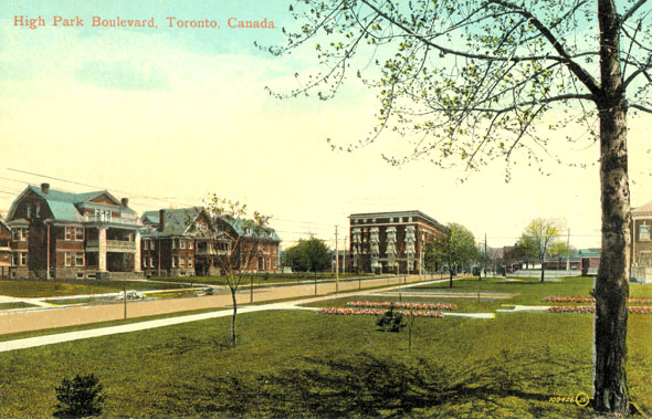
The east wing is obviously in place by the time Valentine & Sons printed the postcard above- a view of the same intersection from the west, looking along High Park Boulevard. Valentine & Sons - based in Dundee, Scotland and "Famous Throughout The World" as their motto proclaimed - are the source for the majority of the postcard images of Toronto taken in the early part of the 20th century, views that are almost stunningly banal, and make us wonder today who, for instance, would buy a postcard image of a tedious stretch of Roncesvalles storefronts, to name one example - a postcard whose rarity has put it beyond my own budget whenever I've encountered one.

High Park Boulevard looking toward Roncesvalles, today
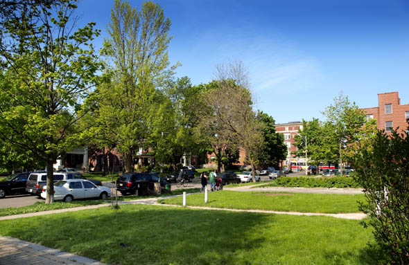
As my attempt to duplicate the image shows, a lot can change in a few decades. You can barely glimpse the old York County S&L offices now through the mature trees along High Park Boulevard today, most of whom weren't even planted before World War One, and the street had the look of a brand new development of monster homes - the sort you'd find in King City today. The three homes on the north side of High Park are still there, hidden behind the foliage, though as Toronto's urban forest canopy is ageing, they might not be if anyone comes back in a decade or so to try and duplicate the old Valentine & Sons postcard.

If anything, these old postcards were the equivalent of e-mail today - "Dear Sir - Sorry it is not convenient for me to have my lesson on Friday the 22nd," wrote one "J. Ettles" to Mr. F. Fowler of 425 Manning Ave. on the back of the postcard at the top of this post. Mr, Mrs. or Miss Ettles didn't even have to bother with a postal code - Fowler's address is simply given as "City," a legacy of a time that was, perhaps, a lot less global than the one we live in now.

Derek on May 25, 2009 at 9:19 AM

I really like these features. Very illuminating.

Ratpick on May 25, 2009 at 9:28 AM

Very cool find. Some people have tried to convince me that the old building was part of a school, which I never quite believed.

Now, if only I could figure out what the story is behind that old institutional building on King West near Portland, just west of the taxi gas station... It doesn't look like anything else in the area and I think it's about to be subjected to the condo-o-matic.

mattyork on May 25, 2009 at 10:30 AM

Very cool story. I actually just rented an apartment in that very building on Fermanaugh. I thought it was a veterans hospital at one point, but I guess I too, was wrong.

W. K. Lis on May 25, 2009 at 10:59 AM

High Park Boulevard (as were other streets in the area) used to have a canopy of elm trees until the 1950's and 1960's. They were taken down due to Dutch Elm disease, and were replaced by non-elm tree saplings.

stro1 on May 25, 2009 at 11:25 AM

Are there any more old images of High Park blvd. anywhere? Specifically of H.P. blvd and Indian rd.?

Nick W on May 25, 2009 at 11:36 AM

@stro1

Have a peek in the archives!

Toronto Archives: Image Search

rick mcginnis on May 25, 2009 at 11:37 AM

W.K. Lis' comment is heartening to me - the elms that were lost to Dutch elm disease were saplings in the postcard, and the trees we see today have grown since then. Replacing and rejuvenating the city's canopy won't be such a hopeless task, then - provided there's a plan for it, but am I being naive in assuming there is?

Fotograf.416 on May 25, 2009 at 11:58 AM

Great post!!! I live right by there, and always wondered what the history of the area was. You could tell it went back nearly a 100 years, but there's really no indication of what it's origins were. I'll never look at this area quite the same ever again.

Andy on May 25, 2009 at 1:09 PM

Great story, and thanks for sharing the old postcards. I used to live in this building and indeed the common belief among tenants was that the building was a former health care facility. The story went something like this: although not designed and built as a hospital, it did serve as an annex of St. Joseph's Hospital at some point in the early 20th Century, perhaps during the recession. Funny, I don't see evidence of the storefronts you mention on that 1914 postcard.

rick mcginnis on May 25, 2009 at 1:54 PM , replying to a comment from Andy

The storefronts appear to be gone by just before WW1, and while I don't doubt Alec, I can't see any evidence of them now - they must have been taken out much earlier. I haven't done a search on the building at Toronto Archives, so I don't have a construction date, though it looks early Edwardian to me - high ceilings, decent air circulation (compared to Victorian structures,) simple, neoclassical ornament.

Jon R on May 25, 2009 at 1:57 PM

is anyone going to say anything about billiards?

ground floor, southwest corner?

Torontonian on May 25, 2009 at 1:58 PM

Could that building have served as the first Our Lady of Mercy
Hospital that was in later times attached to St. Joseph's?
It also helps to remember that the Sisters of St. Joseph also
ran an orphanage in the area. I wonder if this building
could have had something to do with it or as a shelter for
pregnant single women?

John Leeson on May 25, 2009 at 8:21 PM

I wonder if the bureaucrat named "R. Holme Smith" was actually the developer (Robert) Home Smith who bought the lands for and eventually developed the Kingsway neighbourhood. He also founded the Old Mill Inn (where there's now a Home Smith Bar. The city has a park named after him along the Humber River:
http://www.toronto.ca/parks/parks_gardens/homesmith2.htm

rick mcginnis on May 25, 2009 at 8:56 PM , replying to a comment from John Leeson

John, you are in all probability right. Perhaps a change is in order to the entry.

Bubba on May 25, 2009 at 10:37 PM

Great story, makes me think what life was like back then and to see the same structures still in existence today, it gives me hope for the city of Toronto's future.

Rachel on May 26, 2009 at 11:23 AM

Nice post, and great pictures of my old street, High Park Blvd. Searching through the Toronto Archives photos are one of my favourite time killers on slow days at the office.

jlangdon on May 26, 2009 at 10:47 PM , replying to a comment from Ratpick

@ Ratpick
The building on King West that looks like a schoolhouse was The Toronto Silverplate Building, built in 1882. It's going to be restored as part of a condo development called the Fashion House.

sally on May 28, 2009 at 6:11 PM

Great post thanks!
I have lived in the Fermanagh building for 2 years, it has such lovely character..it reminds me of a place I lived in Barcelona.
The units have bay windows, 13 foot ceilings, dumb waitors (now boarded up), air shafts with windows into bathrooms, old clawfoot tubs etc.
It is just so sad that the owners keep gutting all the units and replacing the old real wood floors and cupboards with cheap beige laminate and melamine... I think they are trying to "modernize" it with tragic results.
Up until a few years ago they still had the old elevator with a sliding gate - very impractical, but awesome.
It would be wonderful to have it declared a heritage building. Toronto has so few examples of these types of old residences.

Add a Comment

Name: Email: URL:
Comment: