Wild videos show tornadoes ripping through Ontario amid widespread storm warnings
Residents of parts of Ontario are being instructed to stay inside and head to the lowest point in their home as tornado warnings for communities across the province continue to pile up Thursday afternoon, with at least one active tornado already confirmed.
Shortly before 1 p.m., warnings had been issued for multiple places in the Ottawa region, including Ottawa North, Ottawa South, Kanata and Orleans, with meteorologists calling it "a dangerous and potentially life-threatening situation."
A TORNADO WARNING is currently in effect in Ontario for:
— The Weather Network (@weathernetwork) July 13, 2023
- Ottawa North
- Kanata
- Orleans
- Ottawa South
- Richmond
- Metcalfe
- Prescott
- Russell
This is a dangerous and potentially life-threatening situation. Take cover immediately.#ONstorm #ONwx pic.twitter.com/ppeypJbcjD
Though The Weather Network had warned the public of overnight thunderstorms that could potentially bring heavy rains, intense lightning, hail, and yes, even tornadoes to Southern Ontario last night, citizens were still shocked to see how severe things became, and how quickly they escalated.
A tornado watch for the east of the province and portions of Quebec was upgraded to a warning as conditions worsened today, thanks to a highly turbulent and convective storm system.
If you’re in the south of Ottawa please take the tornado warning seriously & stay safe! ❤️ https://t.co/EGEy1hW9qo
— katie (@itsmitchmarney) July 13, 2023
Roads in and around Toronto were messy and slippery amid torrential downpours early Thursday morning, but things appear to have brightened up in the city as the day has worn on — which is certainly not the case further eastward.
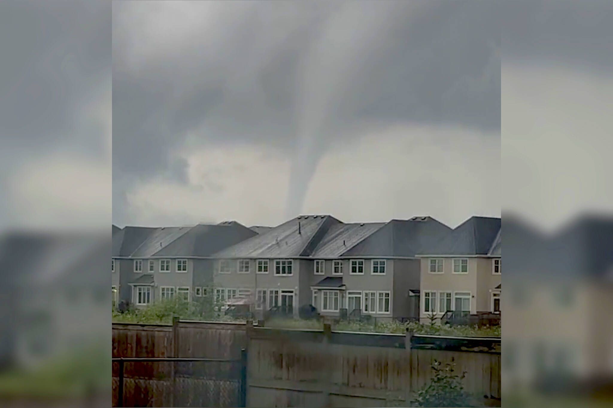
Alarming footage of a tornado touching down in Barrhaven, Ontario — a 25 minute drive south of Ottawa and just over four hours from Toronto — has been popping up on social media, showing terrifyingly powerful winds whipping up shingles and various materials.
Wow - be safe!
— Doug Laurie Sports (@DougLaurieSport) July 13, 2023
A rotating cloud was seen ripping around residential streets in the area under darkened skies as police, firefighters and other emergency personnel responded to the scene.
Locals say that authorities have been knocking on doors on some of the hardest-hit streets to check in and provide assistance, and also to shut down gas and hydro to prevent further issues.
OMG WHAT
— mei-mei☆ (@ightbridgers) July 13, 2023
Around 100 homes have apparently already sustained physical damage, and one injury has been reported thus far.
A tornado has hit Barrhaven, Ontario.
— Simon Storm Frigon (@CDRG_RedTeam) July 13, 2023
Ottawa Police, the Ottawa Fire Department, and paramedics are in the area accessing the damage and providing assistance.
Firefighters are going door to door in the worst areas checking on residents and shutting down gas and hydro on multiple… pic.twitter.com/CefmCMbkWZ
Severe thunderstorms bringing high levels of precipitation and strong winds are expected to keep raging across the Ottawa Valley.
Those in areas with active tornado warnings can anticipate winds up to 100 km/h, and should stay away from mobile shelters, windows and doors, and worst case, cover themselves with a mattress or sleeping bag in their basement, if possible.
Everyone should also keep up to date on the latest news from credible weather agencies, as warnings have been repeatedly issued, ended, and re-issued in the last few hours.
Wow
— MAC (@MACMIK78) July 13, 2023
Toronto is currently an overcast and muggy 23 C that feels more like 26 C, with skies gradually clearing with times of clouds and sun, and no alerts in effect.
Latest Videos
Latest Videos
Join the conversation Load comments