
What Weston Road used to look like in Toronto
Alternately twisty and arrow straight Weston Road makes its way from confusing origins south of St. Clair Ave. to a quiet rural intersection about 40 kilometres north of the city in Holland Marsh. Named for the old village of Weston, which it once primarily served, the road used to be heavily industrial along its southern reaches: factories that made automobiles, boilers, and pianos, as well as manufacturing plants that turned out bags of flour and piles of butchered meat were all common within the Junction.
Before that, the road was little more than a dirt track, as illustrated in the photo above, taken in 1908 near Rogers Road.
Today, there are two Weston Roads. Signs for "Old" Weston Rd. mark the earliest route of the street, east of the railway corridor, while the "Weston Road" that runs south of Rogers Road and intersects with Keele St. is a more recent addition. (In this post, I've used the modern day road names for the sake of clarity.)
This is what Weston Road used to look like in Toronto.
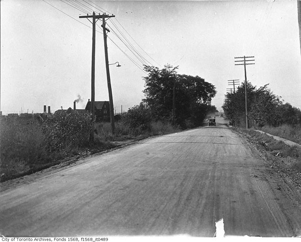
An unpaved Old Weston Rd. north of St. Clair Ave. around 1930.
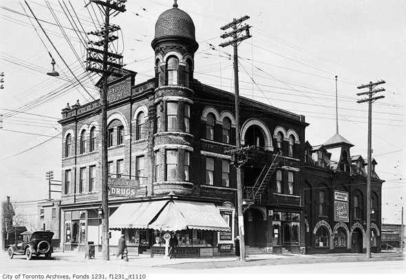
The Heydon House hotel at the northwest corner of today's Old Weston Rd. and St. Clair Ave., which still stands in a heavily altered state, was once the largest hotel in the former independent town of Toronto Junction. As David Wencer writes at Torontoist, the Heydon House used to be a popular drinking hole and cock fighting venue around 1903.
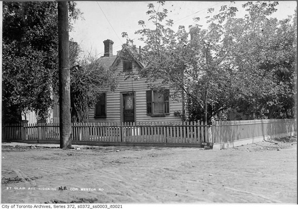
Northeast corner of Old Weston Rd. and St. Clair Ave. in 1911, opposite the Heydon House hotel. The view today is decidedly less bucolic.
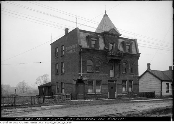
Another bawdy Junction hotel, Brown's was one of the several establishments forced to stop serving alcohol by the passage of a local law enforcing prohibition in 1904.
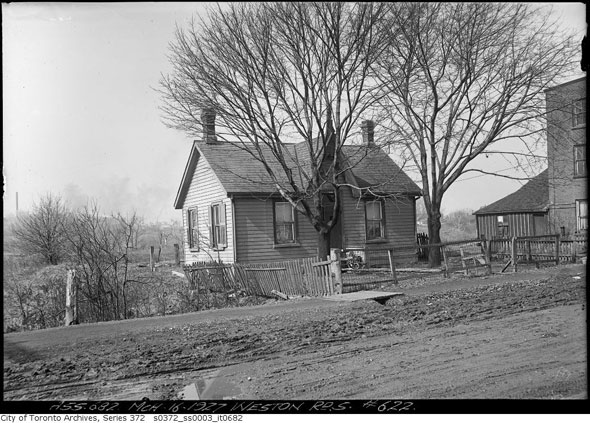
House on Old Weston Rd. near Brown's Hotel before the road was paved. The houses on this strip mostly been rebuilt since this photo was taken.
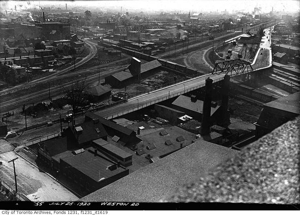
Aerial view of the Canadian National and Canadian Pacific railway intersection that gave the Junction its name. The bridge in the foreground carried Old Weston Rd. over the tracks until it was demolished in the 1970s. The West Toronto Diamond grade separation, which was "substantially completed" in December, has eliminated the direct intersection of tracks in the area.
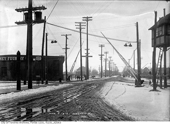
Level crossing on Weston Rd. just north of the West Toronto Diamond, looking north. That elevated signal box on the right of the frame was where engineers controlled rail traffic through the busy intersection. The Gurney Foundry Co., visible on the left, made ovens, boilers, and radiators, many of which are still in use in buildings around the city.
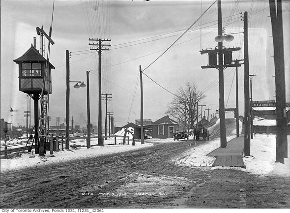
The same view looking south from the level crossing towards the Old Weston Rd. bridge. The signal nearest the control box is pointed down, likely indicating southbound Grand Trunk Railway trains are clear to pass through the junction.
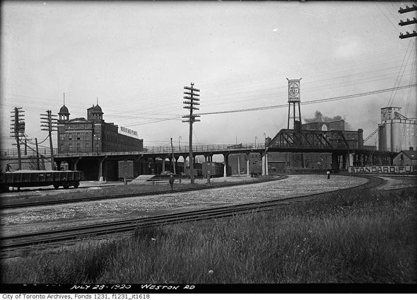
Side view of the Old Weston Rd. bridge over the rail tracks. On the right, The Standard Fuel Co. in front of grain silos and a water tower belonging to the Campbell Flour Mills Ltd. It's hard to tell in this photo, but the Campbell water tower was designed to look like a full bag of flour tied up at the corners (close up.) The advert on the side reads "Cream of the West--The Guaranteed Flour." On the left is a manufacturing plant belonging to Nordheimer Piano Co.
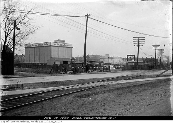
Before ice was readily available in every gas station, corner store, and supermarket, businesses like the Lake Simcoe Ice Company would harvest frozen lake water, ship it to the city, and deliver it to private homes in substantially sized blocks. Lake Simcoe ice was particularly popular thanks in large part to its perceived purity. The facility shown here was located north of the railroad intersection in the Junction.
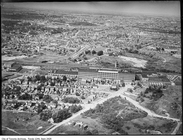
Aerial view of the Willys-Overland auto works around 1930. The company, once one of the Junction's largest employers, produced vehicles out of a plant purchased from the defunct Russell Motor Car Co. on the east side of Weston Rd. at Gunns Rd. in 1916. The right-hand drive "Whippet," exported to Australia and New Zealand, was the plant's main product. The factory closed in 1933 after a brief period during the first world war spent making aircraft engines. Just a few of the old buildings remain.
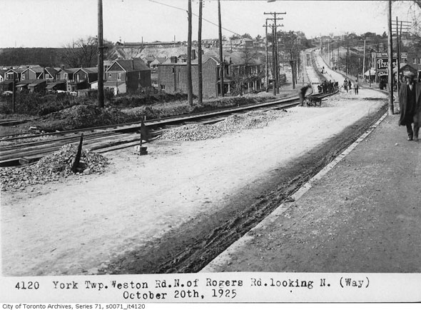
Weston Rd. looking north a few hundred metres north of the intersection with Rogers Rd. during installation of streetcar tracks in 1925. The view today.
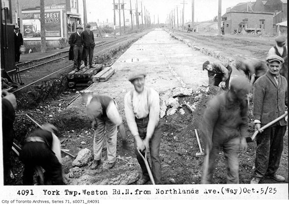
Workers, some laughing, some frowning, laying down streetcar tracks on Weston Rd. near Northlands Ave. in 1926.
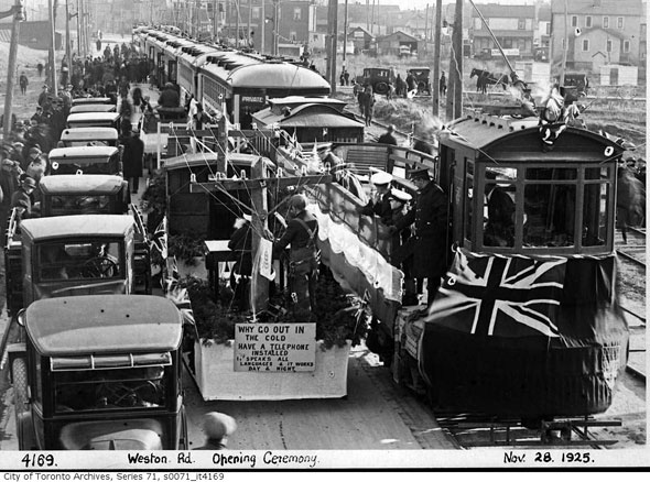
Ceremony celebrating the launch of TTC streetcars on Weston and Rogers roads in 1925. The service lasted until 1940s when it was converted to bus operation. The route ran from Keele and Annette streets north via Weston Rd. to roughly present day Humberview Cres., just south of the 401 overpass.
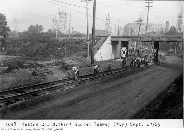
Construction of the underpass beneath the Canadian Pacific line near Oak St. in September 1925. The single track running along the roadway was used by the Weston streetcar. The original 1925 bridge was in the process of being replaced as of 2014.
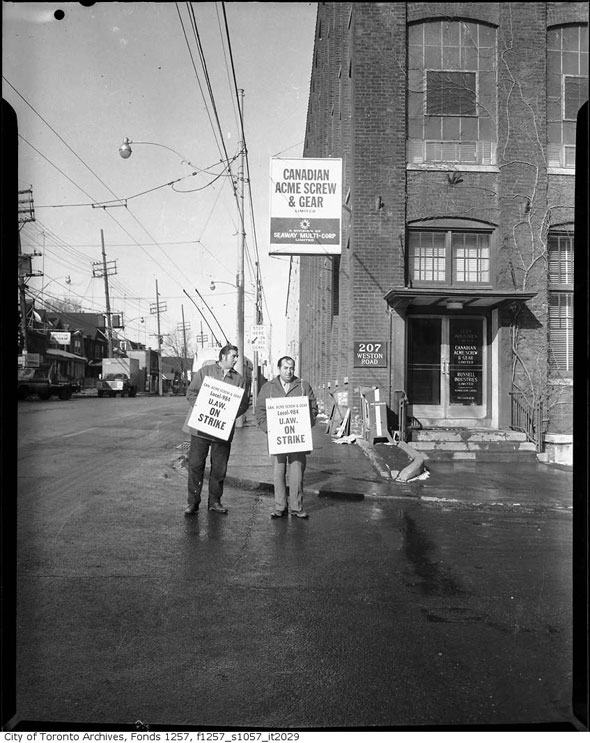
United Auto Workers strike outside Canadian Acme Screw & Gear, a subsidiary of bicycle and auto maker Canadian Cycle and Motor Company (CCM,) in the 1960s.
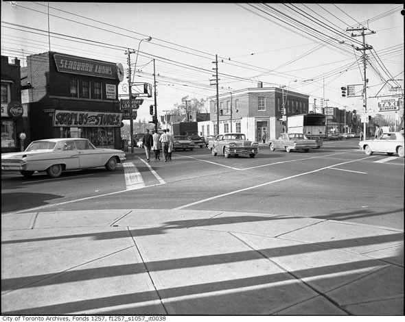
The village of Weston in the 1963, looking west along Lawrence Ave. at Weston Rd. The building on the left advertising Surplus Dept. Stores and Seabond Loans is still standing. The current tenant is a nail salon.
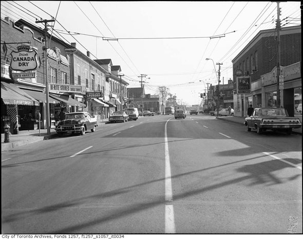
Looking south on Weston Rd. a short distance north of Lawrence in 1963. The buildings housing Lou's Variety (Canada Dry sign,) Bi-Rite Stores, and the laundry are all still standing. The IDA Drugs on the right of the picture has been replaced by a row of stores at the base of a residential high rise.
Chris Bateman is a staff writer at blogTO. Follow him on Twitter at @chrisbateman.
Images: City of Toronto Archives
Latest Videos
Latest Videos
Join the conversation Load comments


