City
The TTC Trip Planner Goes Live
Although it's still in beta, the TTC Trip Planner has gone live and is ready for customer use. News that the planner was set to launch broke about a week and half ago and shortly thereafter an unofficial version temporarily appeared online.
I've been tooling around with the official planner over the course of the evening, and its been spitting out some, let's say, "interesting" route recommendations. When punching in a trip from Christie and Dupont to Queen and Leslie, for instance, I received a suggestion to walk up to Davenport and take the 127 across to Spadina Station.
Although the 127 runs a tad more frequently than the Dupont 26, something about this seemed strange. I soon realized that I'd left the "walking distance to/from my stop" option at the default of 500 metres. When reduced to 250, it suggested the more logical option of waiting for the bus that required no uphill walking.
Okay, I don't expect that the planner will take topography into account when providing route suggestions, but the developers should know that, all things considered, people tend to want to embark from the stop nearest to them. In certain areas, that'll be 500 metres away, but for many it'll be 250 or less.
So why does it default to the longer distance? In this case, it's not as though I'd be saving an abundance of time trudging up to Davenport (although, to be fair, the recommendation is made based on frequency of service).
Another issue my cursory look revealed was how confusing the itinerary summaries can be. Although technically correct, they appear to mislabel subway stop destinations mid-route.
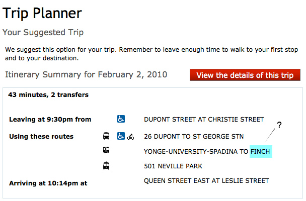
In the above example, it initially appears as though the planner is telling the rider to take the subway to Finch Station. In reality, the reference to Finch is directional, informing the rider of which train to select once he arrives at his subway transfer.
Though this may be obvious to some, I suspect that it'll cause a bit of confusion for more than a few users. In my experience, people tend to think more in terms of north/south and east/west when determining which subway they'll be taking.
Neither of these are major problems. And should they prove as problematic as I fear, a fix would be very easy. But, all in all, my first impression is that the planner is clumsy and not always logical/fully informed in its route selection.
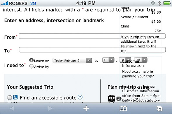
Perhaps more troubling is that the trip planner is not mobile browser-friendly. In fact, this beta release renders quite wonky on the iPhone (see below). The TTC has said that they have intentions to develop a mobile application trip planner down the road.
Admittedly, I've yet to devote enough energy analyzing it to pass judgment with complete confidence. Over the coming days I'll keep plugging away in an attempt to get a read on just how useful/problematic the program is. In the meantime, I'd love to hear what other users have to say (the TTC has, after all, released this beta in hopes of getting user feedback that can be used to make necessary improvements).
Are you pleased with this version of the planner? Are there improvements you'd make? Has it spit out an odd route that you'd like to share?


Discussion
35 Comments
Sort By Oldest First / Newest First
Subscribe
I tried two simple routes (one was direct, the other involved a transfer) that I take often and was led in a most indirect and confusing manner to my destination.
That websites design, interface, terminology and philosophy needs to be completely redone.
There is no baby in that bathwater.
Time to assemble an ever bluer ribbonier panel!
hahahaha!
The problem is it's a bit too specific.
It greatly depends on your walking distance selections as well as your departure/arrival times.
For instance in the above example, Derek may have entered a time when the Dupont & Christie buses were a 25-30 minute wait, but the 127 was coming sooner.
It also needs to list situations when you can take any bus. For example if I want to go from Union to Mt. Pleasant & Eglinton it tells me to take the 54 Lawrence East, but I can really take any bus heading eastbound out of Eglinton Station.
On the same note the Star allows you to leave comments and it says you have 150 words in the box. But as you are typing how are you suppose to know how many words/characters you have left? Are we suppose to count the words as we type? Most newspapers have a word/counter within the box if they limit the length of the comments and I'm no expert but that seems reasonable. But overall I like the Star comment section but they keep closing the comments and don't allow you to say more than 150 words without a counter, not like here on blogto but I think there should be a limit but 150 words is too short.
Daniel .......... Toronto
http://dandmb50.tumblr.com/
amusing how whenever an blog has anything to do with the TTC, every commenter seems to have a carrot up their wazoo.
And why couldn't the TTC choose to integrate with Google Maps' directions search just like VIVA/YRT did?
I'd been using crazedmonkey's ttc map overlay and doing it manually :S
And, there is always complaints about the TTC because the complaints are FULLY JUSTIFIED. I say this fully aware that it is tragically, even criminally, underfunded by the province... but, that does not excuse the poor management (and labour) that exists in the institution. The situation, unfortunately, would probably be no better if the proper amounts of cash were available.
I suppose it's a little shorter walk, but when there's a Dufferin bus stop right at Hallam, it would perhaps make sense to walk an extra few metres and save a bus wait.
lol
MyTTC.ca is great. When visiting on my mobile phone, it automatically knows my current location, and gives me better route options in a simple, clear manner.
I just put in my normal route to work. It suggested I take a bus to the subway station (which is half a block from my apartment). Then take the Dundas street car east instead of the Queen one that drops me off right in front of my work. The Dundas car would have me walking 5-10 minutes after getting off.
I agree that this is a silly waste of money - similar to the system that tells me if my train is coming in 2 or 3 minutes while standing in the station having already paid my fare, what am I going to do with those extra minutes other than stress out if I am already late?
huh, ain't that a pickle.
Gave it a few shots, seems to be working fine.
Also, using one unaffiliated media outlet to leverage your own commercial media outlet? Classy.
Most people know which ways to go in the first place, so this is just a guide if you don't know exactly how to get there, it is not written in stone.
Daniel ......... Toronto
http://dandmb50.tumblr.com/
It would be interesting to see how much they have spent and who developed it.
When I entered a simple route (from Avenue and Eglinton to East York General Hospital), it suggested that I take three busses, and that the trip would take over an hour.
Myttc.ca, on the other hand, gives a logical choice of routes, using the subway for most of the trip, which cuts travel time almost in half (and note that several route choices are offered!).
Typing in locations is ridiculous too. Even if you select a location that appears in the drop-down box as you type, you're still asked to confirm it during the next step. For example, I started typing "East York C", and was given several choices at the drop-down box. I selected "East York Civic Centre", but on the next page those same choices were presented to me, and I had to select "East York Civic Centre" again before proceeding.
I've used trip planners in many different cities, and they all have their issues and quirks. What I do love is that it gives an estimated time, which is great.
Perhaps you should learn some responsibility with regards to your recurring lateness.
@Rachel : The TTC has yet to make the data public so there's a blackout of TTC info on Google Maps. Since York Region Transit does has info available, Google Maps has no choice but to display it if you choose "directions by public transit".