Travel
Cheltenham Badlands and Forks of the Credit
When I was brainstorming ideas for what to do last weekend, a friend suggested we visit the Badlands. Badlands? As in those odd, Mars-like barren dunes you find out west? I told her that sounded swell and all, but this was going to be a one day adventure and a trip to Alberta was out of the question.
No, the Cheltenham Badlands, she said. In Caledon.
Oh. There are badlands in Caledon?
Another friend then piped in and suggested that if we headed that way, we should visit the waterfalls as well.
There are waterfalls in Caledon?
Okay, to anyone from the Caledon region, I apologize and profess my ignorance. Up until now, I only knew of your town as that place north of Brampton, a place I occasionally drove past when I was visiting my relatives in the suburbs. But yes, after spending a sunny afternoon in your home, I admit that a lovely land of rivers and waterfalls and alien hills lies just an hour north on Hwy 10.
First stop: a visit to the Badlands.
The Badlands come up on you quickly. Real quick. Off of Hwy 10, you turn onto Old Baseline Road, and from there, it's up and over a few hills before you are literally on top of them. There's a small parking lot off to the side of the road, then a small embankment, and then, you're there.
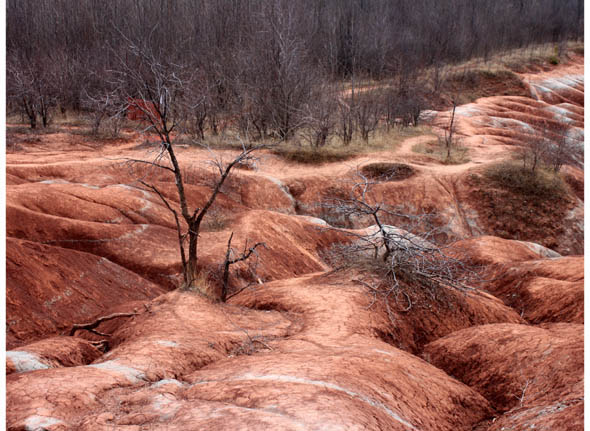
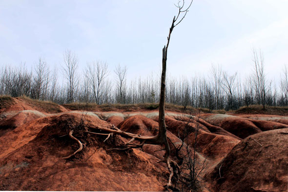
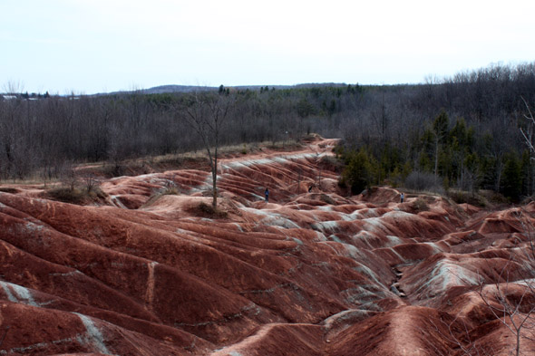
And I must say, they're pretty impressive - all red, rolling hills with streaks of greyish-green, and a few jagged trees for that creepily beautiful look. The whole scene is a bit hypnotizing.
The term "badlands" refers to land that is highly eroded, barren, and dry. The Cheltenham Badlands are the result of a delicate, soft rock called queenston shale. Because the rock is so sensitive, it erodes easily, creating those rolling, red dunes that look like another planet. Badlands are rare in Ontario because in most spots, rocks, sand, and gravel cover and protect any shale, but Cheltenham is considered to be one of the best samples of badlands topography in the province.
They started forming back in the early 1900s, when the land was cleared for farming. The combination of removed vegetation and grazing livestock exposed the shale, and, even though it's no longer used as farmland, Mother Nature has been eroding it ever since.
But, as we reported a few years ago, the Badlands are in danger of their own popularity. When I was there, a handful of people and some rambunctious children were scrambling all over the hills, which as I previously mentioned, are extremely delicate. (Not only that, but there were broken beer bottles scattered in the dirt.) Anyway, the problem (besides the beer) isn't lack of signage, as there's a sign right next to the site, asking people to respect the trails, to stay off the hills, etc.; the problem is that the signage isn't obvious.
I know that large signs would litter up the place, and I definitely don't want a viewing platform installed or a fence marking off where you can stand, but the warning sign is easy to miss. I admit that I walked right past it, and, in my own ignorance, I ventured down onto the hills. It wasn't until I looked down and saw the cracks in the ground beneath me that I thought "hey, maybe I shouldn't be walking here," and then I noticed the sign as I was leaving. Note to hikers: the Bruce Trail passes by the Badlands, but unfortunately, this section of the trail is currently closed for environmental regeneration.
Second stop: Forks of the Credit.
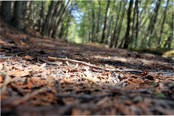
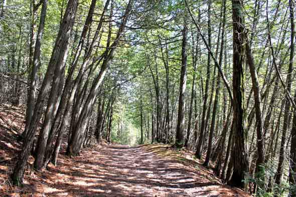
Back in our car, we returned towards Hwy 10 and ventured further north, to Forks of the Credit Road. From there, it's an up-and-down and twisty ride, with the Credit River babbling alongside you. We parked at the railway overpass and followed the nearby Tramble Trail up onto the Niagara Escarpment. The trail starts out steep, but then tapers off, and from there is a lovely shaded walk, past rock cliffs and steep drops, with the rush of the river far below. The entire area is remarkably pretty, and feels completely remote; as we wandered the trails, it was easy to forget that we were only a short drive away from Brampton and Mississauga.
After wandering on the trail, we headed back towards our car and drove further along the Forks of the Credit (more twists and turns, and an uber steep ascent up the Escarpment), towards the tiny village of Belfountain. The town was adorable, but I had yet to see the elusive waterfalls my friend had told me about, and, much to chagrin of my boyfriend, I was getting frustrated and irritable. We spent some time traveling back and forth through town, then back and forth again, looking for a trail marker or some sign from the heavens to guide us. Finally, a local shopkeeper pointed us in the right direction: head north on Mississauga Road, towards Forks of the Credit Provincial Park.
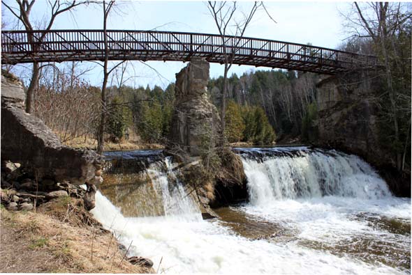
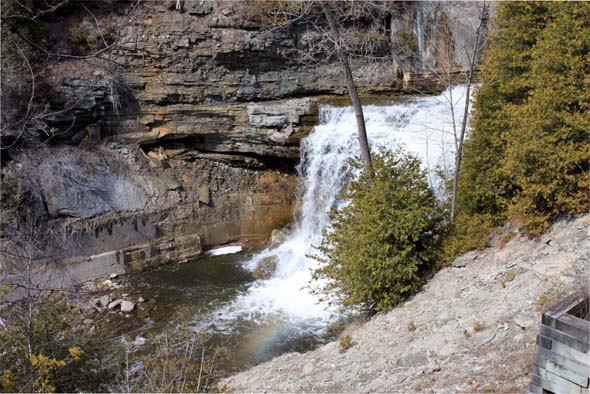
We followed her lead and ended up at the Elora-Cataract Trailway - part of the TransCanada Trail. From there, it's a 20-minute, hot, shade-less walk to the Cataract Falls and the ruins of an old hydro-generating station dating back to 1899. While the falls are pretty and the ruins are cool, they're a bit anti-climactic. The viewing platform doesn't offer the best view, and because of erosion, it's impossible to get any closer to the falls. But really, with how pretty our day tour had been, I couldn't complain.
Tired and feeling a bit sun-stroked, we headed back to our car and ventured home. Dear Caledon: I apologize for ignoring you all these years.
Writing by Tammy Burns. Photos by Stefan Wege.


Discussion
38 Comments
Sort By Oldest First / Newest First
Subscribe
Since when did the GTA encompass Caledon?
http://www.toronto.ca/toronto_facts/diversity.htm
Hell, if you grew up in a family that didn't have their heads so far up their asses, you'd have probably known that already.
Chris...I would argue that most people in Caledon and Brampton know about the forks and these are the places with the...ahem...most "diversity", well Brampton is anyways. Many people go up in the summer for a nice day trip.
Many places in Ontario are becoming over run with 'tourists.' Everything is being fenced off, boarded up and turned into 'parks.' Balls Falls, near Hamilton is one example. Castle Glen, on top of Blue Mtn is another. I was there last Spring and horrified to see that since Blue Mtn now lets the lazy tourists bring their bicycles to the top of the mountain via chair lifts turned into buckets, the tourists have all but destroyed the ruins of the old castle not far from there. For decades, it was a quiet oasis for the locals, but no more.
That's progress in Ontario, I guess.
This writer went out of their way to share an experience that maybe some people didn't know about, some people can relate to having grown up around here, or that some people only want to experience from their desk in pictures...why so much negativity?
How about "hey, nice pictures! looked like a good time!" or "oh I remember going there as a kid!"...it's not so hard to be a little less bitchy about *everything*, some of you should try it.
This area is classified as an United Nations Biosphere Reserve, that is one reason why there is so much concern. The erosion at the Badlands is so bad that there is a possibility of the town building a fence around the whole area so the only way tourists will be able to see the Badlands is through a chain-link fence. I think that would suck!
I'm not being negative I'm just outlining some of the consequences of more people visiting and not reading the signs. No one attacked you and I'm not attacking the writer. No reason to, so should have either.
Sincerely,
S. Brown, PhD. Environmental Policy and Planning
In fact, (chuckling) I just got back from cycling there this morning!
For those unfamiliar with this area, bring your bikes, (forget the territorial folks) get some fantastic great cycling in, and stop by "The Shed" the Belfountain for the best mid-ride latte and scone. Seriously. (That's right folks: I'm letting people know about The Shed. Secret's out!)
Just don't trample the Badlands - take pictures instead :)
While the badlands are beautiful, they ARE an artificial creation. How much energy should we expend to preserve them?
They didn't dig at them with a spoon. Not when they had a perfectly good team of oxen and plowshares.
A great day trip for sure!
Thanks to the poster for his/her comments and for sharing. I would really have expected some more positive feedback.
Please keep in mind that these forums can be very helpful to all travellers, local and foreign, most of whom are looking for a reason to visit your community and trying to find something of geographic or cultural significance which makes your community worth visiting.
I think the pictures are great and I will definitely plan a visit to the Badlands. And now I will include Belfountain and the Forks of the Credit.
I'm grateful for the author posting the story of their trip to the Cheltenham Badlands because it fits my early memory exactly. This is a Sunday drive I will most definitely be taking this summer.
By the way, I'm sure the people who run the ice-cream stand or the coffee place mentioned above, don't mind the visitors. But you don't care about them do you? Who cares how they live as long as only you can see beauty of the Badlands.
Whatever.
Thank you for posting your trip the pictures are beautiful and it was very educational too!
ON topic, fantastic pictures! I live at Derry and Mississauga, road, so just a 25 minute drive from Belfountain/ Badlands. Only discovered the place last summer and make at least 6 or 7 trips with any guests that are in town from overseas or the US. Perhaps some noice and pollution but there is now additional support for the local economy no?
http://www.marsshutters.com/shop/images/gta-map.jpg
That's just one map example I came across.
I lived in Peel from grade 8 through high school and was not aware of the Cheltenham Badlands. Before grade 8 I lived in Orangeville - not too far away from there - and I STILL did not hear about them. It's not safe to assume we all know about the place.
My first visit was today with my husband and my son. I found it quite lovely and wondered what it might look like with the leaves turning or, as in the photos above, prior to leaves growing in.
Locals don't own the land as one commenter seemed to infer. It's owned by Ontario and hiking trails are provided so that we can all enjoy the beauty.
In fairness, however, it's our responsibility to ensure that the rules are followed in order to keep this gem of a landscape from becoming a fenced off, no trespassing, forgotten stretch of land.
Incidentally, though not entirely artificial, it is actually true that man cleared the land and, without protection, the erosion created the site you see. The area is cleared for a cattle field and farming. By the 1930s, there was no vegetation left and farming ceased. With no vegetation to protect the shale, erosion has been running its course from the 1930s to present day.
I plan on heading back. I plan to see the Badlands, the waterfalls and Belfountain. I'll probably stop at Flapjacks for breakfast first because I'm quite certain that local business and many others in the area DO appreciate our tourism.
I live in this beautiful part of Ontario, but have seen what 'visitors' are doing, and it saddens me. By all means visit and admire nature's miracles, but please respect her and the people who live there with her.
I suppose it's possible I just missed it when I changed schools; but I doubt it. Curricula change.
And there are so many awesome geographic features in Ontario, it's hard to fit them all in as well as covering the rest of Canada not to mention even brushing on the high points of the rest of the world.
Most Canadians know there are Rainforests in BC; how many of us know there's a rainforest in the US? Austrailia? China? And so many other places?
your blog? Its very well written; I love what youve got to say.
But maybe you could a little more in the way of content so people could connect with it better.
Youve got an awful lot of text for only having 1 or two images.
Maybe you could space it out better?