Sunday, May 27, 2012Partly Cloudy 15°C
Tech

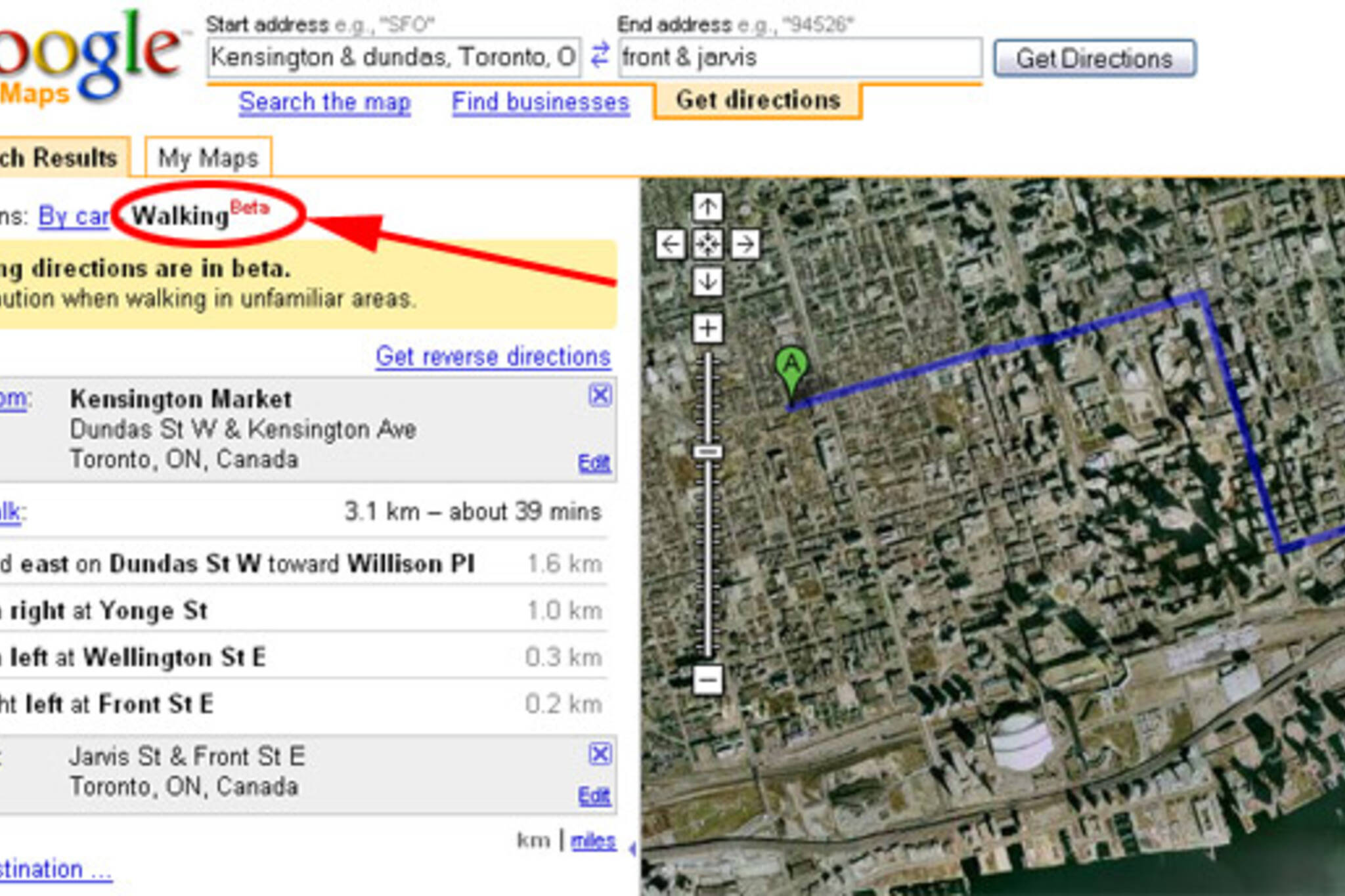
Google Maps - Pedestrian Version

Posted by Jerrold Litwinenko / July 24, 2008

google maps toronto walkingHow long does it take to walk from Kensington Market to St.Lawrence Market?

39 minutes, according to Google Maps new Beta "Walking" feature.

Finally, there's a reasonable way to estimate strolling times in the city. This should be a welcome Google Maps feature for the many people who prefer to use their feet over driving, cycling, and TTCing. It'll be especially useful for tourists who aren't familiar with the city.

Of course, people walk at different speeds, traffic signals can vary, sidewalk closures for construction won't be taken into account, and a lot of options for alternative routes will make walk times (and scenery, safety, etc.) variable.

I played around with it a bit this morning, and both calculated short and long walks seem to be accurate enough for my liking. This should come in handy from time to time. Much like (shameless plug) the blogTO neighbourhood maps do.

Discussion

25 Comments

Randi / July 24, 2008 at 11:48 am
user-pic
I am stupidly excited about this. Whee!!
Adam / July 24, 2008 at 11:51 am
user-pic
Very cool. So I guess the main difference is that it will give you directions up one-way streets, consider alleyways and pedestrian only areas. It's pretty much a 'direct' route as opposed to obeying the rules of the road.
Adam / July 24, 2008 at 11:51 am
user-pic
About time they realized that in an urban setting, most of us do not drive.
somechick / July 24, 2008 at 11:59 am
user-pic
As an avid "walker" I find this quite useful!!! Good idea. Although walking times can vary...it's nice that they'd use side streets aswell. Taking side streets is sometimes faster than walking on a crowded main street.
Maria / July 24, 2008 at 12:01 pm
user-pic
People do realize that you can drag the route and choose it yourself, right? also with the "driving" Google Maps.
Jerrold / July 24, 2008 at 12:06 pm
user-pic
Yes, you can drag to create custom routes. I played around with the one linked above, and it reminded me of the classic <a href="http://www.math.hmc.edu/funfacts/ffiles/30003.3.shtml";>Devil's Staircase</a>.
Teena in Toronto / July 24, 2008 at 12:07 pm
user-pic
Very cool!
seven / July 24, 2008 at 12:17 pm
user-pic
Needs some work.It directs you around parks instead of walking across them.
Lanky / July 24, 2008 at 12:18 pm
user-pic
I walk a lot, and played around a bit with this beta. Pretty accurate for me. Very nice.
Chris Orbz / July 24, 2008 at 12:24 pm
user-pic
Would be nice to have some way to adjust the time estimate to suit different individuals... I walk much faster than most ppl I know, to the point that most days I find myself yelled at at least once for it.
Anna / July 24, 2008 at 12:31 pm
user-pic
at 6'2" I definitely walk faster too. Maybe they need to factor in height as well as a "will you be window shopping button".
tripper / July 24, 2008 at 12:32 pm
user-pic
Super cool. Just yesterday I was Google-mapping some directions and thinking about how car-centric it was.

OK, it takes 7 minutes by car, but how long is the walk? And do I have to make all those stupid turns? Etc.
Lisa / July 24, 2008 at 12:47 pm
user-pic
my initial reaction is Yippie... now to see how it translates for me...
Ben / July 24, 2008 at 12:58 pm
user-pic
Thanks for the measure theory flashback, Jerrold.
megan mooney / July 24, 2008 at 02:52 pm
user-pic
Now they just need one that somehow combines public transit and walking, and maybe one that you could use for biking that would indicate bike paths, roads with bike lanes etc.
scatterbrain / July 24, 2008 at 02:54 pm
user-pic
very good.
I walk everyday to work from Bay/Boor to Bay/King and it takes me about 30 min and it says here its 37 min. I can live with that.
Jerrold / July 24, 2008 at 03:32 pm
user-pic
Related:

Why isn't Toronto in the <a href="http://www.google.com/transit";>Google Transit</a> list?
Roger / July 24, 2008 at 04:11 pm
user-pic
Jerrold, <a href="http://groups.google.com/group/googletransit/web/why-isnt-my-city-included"; target="_blank">here is your answer</a>.
rek / July 24, 2008 at 04:25 pm
user-pic
It doesn't treat parks as pedestrian pathways. It'll follow a path into a park, but it won't cross the grass where the path ends or turns in a different direction.
Gloria / July 24, 2008 at 04:47 pm
user-pic
Not sure why you need Google to calculate a customized walking speed for you -- seems needlessly complex. If you walk faster than normal, just say, "Ok, Google says 39 min for the 'average person', so it'll be LESS than 39 min for me."
bbpsi / July 24, 2008 at 10:31 pm
user-pic
"It doesn't treat parks as pedestrian pathways. It'll follow a path into a park, but it won't cross the grass where the path ends or turns in a different direction."

The problem here, of course, is that the mapping data simply isn't available. All of the information google has available is oriented towards vehicles, and I doubt anyone's really ever given any serious thought to computerized mapping data that indicates, "yes, it is possible to pass through this big area labelled 'High Park.'" There just isn't (or at least, wasn't) the demand for it, so who would bother to plot the data?

I'd expect its something that you'll see change, albeit slowly.. these things take time. Kudos to google for making the effort to introduce the feature!
interro / July 24, 2008 at 11:12 pm
user-pic
I walk to work every day. It takes me ~20 minutes. Google tells me it should take 34. I am awesome.
chephy / July 25, 2008 at 01:06 pm
user-pic
I don't get the hype. I think it's pretty useless. When choosing to walk somewhere, I'd rather pick a route myself. And it's very easy to estimate distance and therefore time that it would take me. Really, just typing all that info into Google would take longer and result in an inferior route that you have to tweak manually.

But then, I don't see much point in those driving direction thingies either.
ang / July 25, 2008 at 01:27 pm
user-pic
"I don't get the hype. I think it's pretty useless. When choosing to walk somewhere, I'd rather pick a route myself."

I use google maps when I DON'T know where I'm going. The point of getting directions is because you can't choose your own route.
Sean M / July 26, 2008 at 01:06 pm
user-pic
It would be nice if Google corrected the locations of the subway stations - Warden is at Danforth and Warden, not St. Clair and Warden, Wilson station is at Keele, not at the Allen.

Neat feature, but like a lot of Google's mapping, needs some work.

Add a Comment

Other Cities: VancouverMontreal