City
These are the Murdered in your Neighbourhood

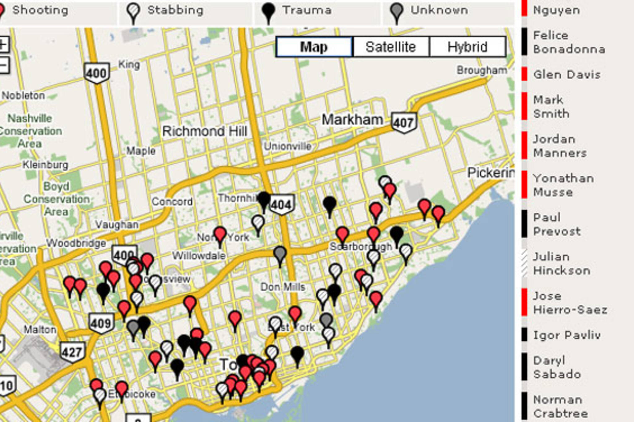
Here's something rather morbid but somewhat useful - a Google maps mashup from the CBC that allows viewers to pinpoint and track murder victims in Toronto. The map displays homicides by type (shooting, stabbing, trauma, or unknown), has a chronological list of victims names, and is updated with every unfortunate subsequent murder the city notches.
Here's the most recent entry:
Nov. 6 - Homicide #74 Shooting Name: Dwayne Norris Campbell Age: 27 Location: 285 Shuter Street Summary: The victim's body was found sprawled near an elevator on the seventh floor of the downtown apartment building. The building has video surveillance cameras and police hope the images will help in their investigation.What can we glean from this map/tracking project?
---
A few things that are immediately obvious (and some may correspond to our expectations):
- Murders by guns are rather widespread across the entire city, although there do seem to be a couple of clusters in the downtown core and in the Jane/Finch areas.
- Don Mills looks like the eye of the hurricane (a safer spot).
- Scarborough appears to have more stabbing murders than other regions of the city.
- Four of 74 victims have not been identified
- We're on pace to see more murders this year than 2005 (78) and have already seen more than in all of 2006 (70).
The Toronto Star also has detailed homicide maps that show victims by age and gender as well, and allows viewers to see records for regions outside of Toronto (Peel, Halton, Durham, and York).


Discussion
10 Comments
Sort By Oldest First / Newest First
Subscribe
i definitely expected the homicides to be more concentrated in the two or three areas we seem to hear so much about in terms of violence.
and you don't think they are? I see three definite areas of concentration - Rexdale & the Jane St strip, the downtown east side, and Scarborough. That's certainly my list, is it not yours?
Actually, no. There aren't any murdered people in my neighborhood. God bless the geriatrics!
Hey, they screwed up... I was wondering why Jeffrey Delgado wasn't listed, he was stabbed to death and left behind the Starbucks at Bathurst & Sheppard, my old area... really shook people up, but that intersection's clean on the map. For some reason, the map's listing him down at 624 Vaughan Road, by Honest Ed's.
I mean, I don't know where the murder actually took place, but given that from what I've heard the accused worked at the Bathurst/Sheppard Dominion and the body was found behind the same plaza, I doubt this took place downtown.
Good observation, Chris. Looks like the Star map got it right and the CBC map got it wrong.
And 624 Vaughan Road isn't exactly close to Honest Ed's!
Whooops, yeah I just Google'd that and boy was I ever off. I was very zoomed out on the map and confused Vaughan with Markham, which I think is understandable. :P
REST IN PEACE JORDAN MANNERS, EPHRAIM BROWN, PATRICK LIM, RICHARD GYAMFI, ALLEN BENN, CHRISTOPHER JOHNSON, RACHEL ALLEYNE. JANE AND FINCH NEEDS TO COME TOGETHER.
Great post! I'm really interested in cartographic/demographic city thinking.. It really helps people get a better sense of what is going on in their city and where it happens. We tend to be lazy in understanding where violence takes place in the city, and it often doesn't fit into neat and tidy generalizations of safe/not safe neighbourhoods (although you can definitely see disturbing trends once you spatialize a dataset).
If anybody is interested in this type of mashup work, you need to look at Adrian Holovaty's Chicago Crime and the Stamen design Oakland Crimespotting. I posted a long text discussing these projects on my blog in October.
toronto really needsz 2 calm down n stop wid da trynna act hard shytt...cuz at da end we jus killin each otha 2 make ppl scared of us n for no damn reason like 4 real...R.I.P RICHARD u will alwaiisz b in ma heart no mattah what..ONLY GOD KNOWSsz y a person would wanna kill an innocent angel like richard ma close frenn(L)